
1WH. Two miles east of Stonehenge.
Woodhenge comprises a circular ditch and bank with 168 upright posts, originally timber, forming six geometric eggs at its centre. This geometric and astronomical marvel overlooks the massive Durrington Walls Henge and its Southern Circle. The Southern Circle is a similar timber monument that also features six geometric eggs.
All three monuments were designed by the Beaker People from the continent, who had their own system of measurement, built timber and stone circles based on Pythagorean and near-Pythagorean triangles, and, judging by the Southern Circle, could count.

2WH. My model of Woodhenge. It's an old photograph, but it shows Woodhenge as it might have looked when summer-solstice sunlight passed through it. This view also shows Ring C with lintels, like Stonehenge. However, Woodhenge’s timber posts were buried so deeply that they might have been self-supporting.

3WH. The 2008 GPS survey of Woodhenge.
Of all the monuments built during the late Stone Age, Woodhenge, less than two miles from Stonehenge, shows what Stonehenge was intended to be.
Unfortunately, the proof relies heavily on two points...
1. Archaeological acceptance of the 2008 survey as accurate. (English Heritage have held the survey results for the past 18 years.)
2. Accepting Woodhenge's axis of symmetry as pointing to the 18.61-year northernmost rising of the Moon - a Lunistice.
The northernmost moonrise, when the moon rises over Sidbury Hill, is the only one we are concerned with here. This Lunistice lies 9 degrees further north than the summer solstice. Not everyone is happy to use the word 'Lunistice', but we use it for simplicity.
Few revellers realise that when watching the sunrise from Stonehenge on 21 June, if they had arrived a couple of days earlier and stayed for four days, the sun would appear not to have moved at all. Thus, the word 'Solstice', which in Latin means the sun stands still.
The moon also stands still when it reaches its furthest point north every 19 years, but this is much less obvious. It does not appear day after day like the sun, but only at monthly intervals. You also need to know the exact time and date, whether it is daytime or nighttime, and the weather.
The 2025 Lunistice has already passed us by. The moon appeared near the Lunistice at night in September, again in October, in the evening in November, and in the afternoon in January.
It’s also worth noting that the Lunistice cannot be seen rising above the horizon on a bright afternoon, as in January, and the viewer has to be content with a view when it is much higher in the sky.
Stone Age man had to contend with these difficulties when observing the moon. The moon is hardly visible during the day, and the far horizon is invisible at night. But they did deal with it. After many years of study, they were able to predict where the moon would break free of the horizon and mark its position with lit braziers.
As a mark of respect, they also paved the summit of Sidbury Hill with river gravel and rolled stones. But which river, the Avon or the Winterborne near Avebury? An exchange is likely. See the gravel heap discovered beneath Silbury Hill. No one is sure where that deposit came from, except that it was not local.
*********
Maud Cunnington and her husband stripped Woodhenge bare in 1926, 27 and 28. She then had concrete posts placed where timber posts, fashioned from whole tree trunks, had stood in Bronze Age times.
Reassuringly, some of Woodhenge's concrete posts were removed during archaeological excavations by the Stonehenge Riverside Project in 2005 to investigate a possible stone cove. These posts were found to be accurately placed relative to their original Bronze Age positions.
Our picture shows the Jenks brothers surveying the concrete posts with GPS in 2008, producing what is now known as a moon egg. We will also prove archaeological corruption.
Many people consider the Woodhenge plan by Professor Alexander Thom the authoritative version. However, we dismiss Thom's plan as fraudulent because it was produced undersized and skewed clockwise, thereby giving a false preference to the sun.
Eggs have a pointy end and an obtuse one, which gives them an axis. Woodhenge's four outer eggs share the same axis and point towards the moon, whereas the two inner eggs look through the 50-degree axis that points towards the summer solstice.

4WH. WOODHENGE. 2008 GPS survey results.

5WH. Woodhenge’s outer ring, Ring A, generated in CAD from the 2008 GPS survey.
Eggs are ‘pointy’ things, and Ring A is egg-shaped, with its pointy end facing the northernmost moonrise.
Ring A is based on non-Pythagorean triangles measuring 7, 15.5, 17 (17.007 megalithic yards).
Axis of symmetry. Azimuth 40 degrees.
Circle diameters of 46, 47 and 47 megalithic yards with a blend radius of 40.
Average post diameter. 0.46 My.
The 47 My-diameter circles are stepped over by a further 1 My each, increasing the width of this egg in the southwest and southeast. We also find this pattern in the outer rings of Callanish I, Castle Rigg in Cumbria, and Durrington Wall’s Southern Circle. So, this three-ring egg is not unique.
We add some extra posts from other rings to show how the Beaker People, who were not happy with astronomical alignments, organised them to within 10 degrees when designing Woodhenge and Stonehenge.

6WH. Woodhenge Ring B.
Non-Pythagorean triangles of 6, 35.5, and 36 (36.004 megalithic yards). Circle diameters of 40 and 41 megalithic yards, with a blend radius of 56.5 My. Average post diameter 0.54 My. Shares the same 40-degree axis as Ring A.

7WH. Woodhenge Rings A and C. IMAGE POSTED 13 FEBRUARY 2026.
By bringing Ring A and Ring C together, we reveal an offset between their geometries. Thus, Woodhenge, like Stonehenge, exhibits two axes of symmetry, 18 megalithic inches apart.
Ring C has 16 posts, shown in red, each with a diameter of one megalithic yard (0.83 m). It is based on non-Pythagorean triangles measuring 6.5 by 20.5 by 21.5 megalithic yards, with two circles of 28 and 30 megalithic yards. The blend radius is 35.5. The axis azimuth is 40 degrees.
Woodhenge Hypothesis.
Despite its complexity, Woodhenge comes down to something as simple as a moon egg intended to be fertilised by the sun at the summer solstice and taking the child, or her spirit, with it.
The Woodhenge hypothesis implies that Stonehenge is for something equally simple - A baby sun!

8WH. HOW DID WE DO IT? IMAGE POSTED 13 FEBRUARY 2026.
It was done by carefully imposing Ring F over Ring E to find a mismatch of 18 megalithic inches.
You are looking at the true solstice corridor of Woodhenge. It is only 18 megalithic inches wide.
An extra corridor on the moon's major standstills is a bonus.
Does anyone still doubt the Stone Age 10-degree rule?
Does anyone still doubt that Woodhenge's axis of symmetry points towards the northernmost rising moon?
Is it time to re-evaluate the whole of Professor Alexander Thom's work? Yes it is!
After all, he had only a pencil and paper with which to plot his surveys. Today, we have CAD.

9WH. WOODHENGE, BUT NOT HOW YOU HAVE EVER SEEN IT. IMAGE POSTED 13 FEBRUARY 2026.
Designed by beaker folk who shifted the geometry of its six eggs to create several 18-megalithic-inch-wide corridors that match Stonehenge.
Generated in CAD from the 2008 survey, it is all it takes to prove that Woodhenge is a moon egg.

11WH. Photo taken in bright sunlight on the second of December 2026 at two o'clock in the afternoon.
Marked on their tops with black paint, the supernumerary Posts a and b were the first to be placed on the site and play no part in the egg-shapes. These posts were set in place to give the beaker people geometers an exact 50-degree angle from the north.
The alignment threads to the right of b and to the left of a, as shown in the picture. We mark it with a dotted white line and a pair of bamboo canes. Both canes have been topped with a white circle to aid identification.

12WH. CAN YOU SEE THE MOON ?
Taken in bright sunlight on the afternoon of the second of January 2026. The moon shown here is on its way back south after falling short of the Lunistice by one degree.
One thing is obvious, though, the moon rises well to the north (Left) of the solstice.
There should be no need for photographs like this one to help prove Woodhenge to be a moon egg. Consider this....
Quote: Using the methods of modern astronomy and 'winding back the clock'- we can determine almost exactly where the sun, moon, planets and stars appeared in the sky from anywhere at anytime in the past. Unquote.
Stonehenge: Sighting the sun. P. 26. Ruggles 2024.

12WH. I took this photo of the summer solstice sunrise at Woodhenge in 2009. The white tapes, placed before sunrise, show that I was able to predict the solstice and the 19-year Lunistice even then. The picture also shows that it was taken before I linked these alignments to Woodhenge's posts. However, If this photo had been taken 4.500 years ago, the sun would be well to the left as shown here.
Woodhenge consists of six unique geometric eggs based on Pythagorean triangles. These eggs were carefully measured using the Megalithic Yard. These eggs are not simple circles, as Professor Mike Parker Pearson said on TV. Professor Pearson is trying to fill our heads with misinformation.
The four outer eggs aim at the Major Standstill of the moon with a 40-degree clockwise-from-the-north axis.
The inner eggs, E and F, aim 50 degrees clockwise from the north and are therefore aligned on the summer solstice to fertilise Woodhenge while gathering the spirit of the girl child with a cleft skull buried in the middle of the monument. This suggests that the girl was sacrificed.
So, Woodhenge is one key that unlocks the hypothesis of Stonehenge. Avebury's West Kennet Avenue is another. What do you think Stone Age folks hoped to achieve by burying a girl inside a moon egg and fertilising it with sunlight?
Meanwhile, the information board on the site continues to claim that Woodhenge points at the sun. This board, like the original, is corrupt. Shifting the Open University on this issue has proved to be impossible.
I couldn't help but notice, on my January 2025 visit, that Professor Thom's datum post, which he placed in the middle of Woodhenge for his personal use, had been removed. This will prevent others from surveying the site in the same way as Thom did.

Image of woodhenge found in Megalithic Sites in Britain, 1967, by Alexander Thom. page 74.
After all, he had only a pencil and paper to plot his surveys. Today, we have CAD.
Thom considered that all six profiles and geometries were based on a pair of much reduced 12:35:37 Pythagorean triangles. As an experiment we plotted the outer ring as Thom suggested to show just how inaccurate it is.
The outer Ring A. Pythagorean triangles measuring 6, 17.5, and 18.5 megalithic yards.
A 46 My diameter circle is cast from 'point b' of the triangle, and a 48 My diameter from point a'.
Blend radius is 41.51.
Although anyone can see that the geometry is an ill fit to Ring A we found that orienting it 40 degrees clockwise from the north gives a goood fit towards the northernmost rising moon.
It will take a great deal to convince the Open University and English Heritage that Woodhenge is aligned with the northernmost moonrise, thereby defining it as a moon egg. Perhaps this image, in which Alexander Thom's 6:17.5:18.5 triangle and geometry have been superimposed over his plot, might change some minds.
Clearly, Thom's geometry does not fit well within Ring A or any other ring and his geometry is nine-degrees out. Furthermore his plot is 12.6 imperial inches undersized. However, his scale agrees with ours.
POSTED 19 FEBRUARY 2026...
Recent evidence suggests that Professor Alexander Thom did not set out to deceive. His complex maths deceived him. Thom’s survey of Woodhenge is as accurate as any ever made. Or it was, before he meddled with it.
Thom failed to resolve Woodhenge and the geometry of its six eggs because of the complexity of his mathematics, which accepts only Pythagorean triangles, or triples, as they say these days.
In fact, his maths allowed him only one Pythagorean triangle: a 12, 35, 37, and its derivatives. And even that was wrong.
Utterly convinced that his maths was right, Thom based every egg on this single 12-35-37 triangle.
Thom was not completely fooled, however, because he saw that his geometry was undersized relative to the survey he found on the ground.
It seemed the only conclusion Thom could reach was that his steel rule had stretched a little.
This explains why he deducted 0.06% from his measurements in an attempt to put matters right.
Although we show only Thom’s suggested profile for Ring A above, a closer inspection shows that all of Thom’s profiles are incorrect.
From the beaker people's perspective, once they had discovered the 3-4-5 triangle, they looked for more, of different sizes.
It mattered little whether some of those triangles were non-Pythagorean, simply because they couldn't tell the difference.
For example…
Ring A triangle. 7-15.5-17 My. The actual hypotenuse, rounded to three decimal places, is 17.007 My.
Ring B triangle. 6-35.5-36 My. The actual hypotenuse to three decimal places would be 36.003 My.
Ring C triangle. 6.5-20.5-21.5 My. The actual hypotenuse, rounded to three decimal places, is 21.506 MY
Similar problems exist when dealing with the blend radii of Woodhenge's rings.
We cannot expect more from a generation that lived 4,500 years ago.
*******
Ordinarily, Thom’s Woodhenge survey would have sounded the death knell for his Megalithic Yard. But he realised that a survey of Avebury’s outer stone circuit would be so large that it could absorb any error. Despite incorrectly surveying through the centres of the stones rather than against their inner faces, Thom refined his ‘Yard’ to 0.83 metres (2.722 feet).
By combining Ordnance Survey maps with professional vertical photography, this author has verified Thom’s survey and identified another 3-4-5 triangle that Thom overlooked. Otherwise, we find Thom’s survey of Avebury and his ‘yard’ to be accurate.
********
There is a danger in referring to AI in archaeology.
AI rightly draws on information from professionals and scientists, as it should.
But what if some scientists have a corrupt agenda, such as archaeologists swayed by the money Stonehenge makes?
That is the situation today: archaeological rubbish goes in, and archaeological rubbish comes out.


Woodhenge Egg C.
Ring C was built using sixteen posts, each with a diameter of one megalithic yard. Uniquely, these posts create three similar profiles aligned to Az 40.
Perhaps the most important is the outer profile with its 36 megalithic yard blend radius reminiscent of Stonehenge's diameter. The number three held great significance for geometers during the Bronze Age.
The ring is constructed around triangles that measure 6.5 by 20.5 by 21.5 megalithic yards.

49. The Stone Age 10-degree rule as applied to Woodhenge. The image respects the North.
Hugo Jenks deserves credit for discovering that the posts of Ring C depict multiple 10-degree angles. Further consideration showed that Hugo's 10-degree alignments should pass through all six rings, as described above.
We now understand why many posts seem to be in the wrong place. They are offset from the geometry to adhere to the Stone Age 10-degree rule. This rule is followed by Stonehenge, Durrington's Northern Circle, Arminghall Henge, Scottish Callanish 1, and many others.
Woodhenge's solstice corridor is precisely 50 degrees clockwise from the north, similar to Stonehenge.
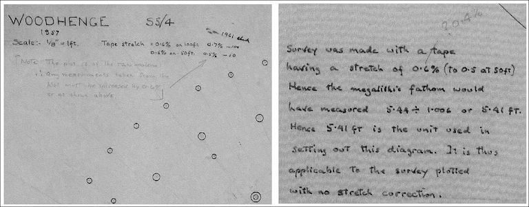
54. The following is how Professor Alexander Thom corrupted his survey of Woodhenge to hide its true purpose.
This author has comprehensively shown that Woodhenge's outer eggs are aligned on the moon. So why do archaeologists still ignore the facts? For an answer, let's consider why Professor Alexander Thom made such a mess of his Woodhenge survey - AND, in his hand-written notes.
Please don’t try to understand Thom's grammar, for it is way over the top.
Thom's handwriting, seen on the right, says.....
"Survey was made with a tape having a stretch of 0.6% (to 0.5 at 50 feet). Hence the megalithic fathom would have measured 5.44 divided by 1.006 or 5.41 feet. Hence, 5.41 feet is the unit used in setting out this diagram. It is thus applicable to the survey plotted with no stretch correction."
Also, note his pencilled correction of ?0.4% when AT wonders if 0.4% might be better than 0.6%.
Thom's diagram on the left says...
"Tape stretch 0.6% on 100 feet, 0.5% on 50 feet. Note: The plot is of the raw material; therefore, any measurements taken from the plot must be increased by 0.6% or as shown above.
As you can see, AT complained that he had measured Woodhenge with a flexible tape and claimed to have estimated precisely how much was needed to be deducted from his measurements to put things right. This is a blatant lie because he is known to use steel tape.
Quote. "A careful survey, using a steel tape and theodolite, was made of the concrete posts (Avebury) that the excavators placed in the post-holes in the chalk." Megalithic Sites In Britain. A Thom, Oxford University Press, 1967.
The concrete datum post (now removed) in the centre of Woodhenge is a modern fixture for surveys. It was probably placed there for Professor Thom's sole use. Thom took his measurements from the centre of this post, which remains on-site.
When living in Oxford, A T could have taken the short trip to Woodhenge to put matters right. But he did not bother. One single measurement, taken as a check like the one I took, could have resolved it.
So, the conclusion must be that Alexander Thom deliberately distorted his Woodhenge plan by making an undersized plot.
Thom's plot of the outer egg (Thom himself called Woodhenge an egg) is proven by CAD as 12.6 inches undersize (0.32 Metres). And if all this wasn’t bad enough, he skewed his plan to make it look like its six eggs were aligned with the sun when they were not.
Professor Thom, a highly skilled engineer with an Oxford University Department of Engineering named after him, was incapable of such obvious mistakes but had an ulterior motive for abandoning his cherished Megalithic Yard.
The images seen above are from Alexander Thom's notebook, which Edinburgh Museum gratefully provided. The museum also provided me with Thom's coordinates, which, when plotted on a computer, give a plot of Woodhenge that is, incidentally, upside down.
There is no escaping the fact that Professor Thom was a good guy until he came to Wiltshire and met the archaeologists researching Stonehenge. This would have been in the 1950s.
Living in Dunlop in Scotland in his formative years, AT was a keen and qualified engineer who proved that Scotland's many stone circles, flatted circles, and egg shapes were all measured using one common standard of length. He named this standard "The Megalithic Yard."
Dismayed archaeologists protested strongly against Thom’s discovery that Woodhenge was a geometric moon egg based on the Megalithic Yard. They wanted Woodhenge and Stonehenge to be maintained as mysteries for profit, whereas Thom’s survey of Woodhenge gave away the whole Stone Age hypothesis in one go!
Hence, archaeologists requested, and some insisted, that he disguise the truth by distorting his Woodhenge plan out of all recognition.
So, despite the years of hoping to gain acceptance for his Megalithic Yard, Sandy Thom complied with the request and produced a corrupted plan by deducting a small amount from every one of his measurements. He also twisted the plot of this egg clockwise to miss the moon and point towards the mid-June sun instead.
However, Sandy made one big mistake. The position of one timber post of Ring A escaped the treatment. Like a signature of deceit, that post identifies Thom's survey as corrupt for being the only post in its proper place!
My folded tracings, which I made in 2007, proved Woodhenge to point at the moon, as did the 2008 GPS survey.
Thom's 'Yard' came under much criticism from the establishment and was told, despite having surveyed more than 400 stone circles - to go away and prove it by measuring even more!
Well, he did; he went for the biggy - Avebury. Not that it did him much good.
******
I’m not the first to make folded tracings of Woodhenge that prove the monument to be aligned on the moon. C. R. Musson, an architect, writing in the appendix of Wainwright and Longworth’s book ‘Durrington Walls,’ (Also Cunnington's book "Woodhenge"), had already made tracings in 1971 to prove that Woodhenge points at the moon. Unfortunately, Musson, too, was ignored.
Quote... Wainwright has advanced some objections to Thom’s propositions, and a purely visual study of the published plans made during the preparations of these notes raises further doubts about some of Thom’s analyses. In this study, as smooth a line as possible was drawn through each ring of post holes: this was then copied on tracing paper, reversed, and adjusted over the original drawing until the closest fit was judged to have been obtained: the long axis of the rings – as actually dug – could then be found by simple graphical method. The orientations so obtained were as follows:
Axis of rings (From Cunnington’s book of Woodhenge) AB 36.5, CF 40.5, and DE 43.5 degrees.
Axis of rings (Thom’s) AB 44.0, CF 47.0, and DE 48.5 degrees.
C. R. Musson 1971 (architect) Durrington Walls 1966-1968. Society of Antiquaries, London 1971, p 374.
Averaging Musson’s results gives 43.33 degrees, which is some 6.5 degrees to the north of the solstice and, therefore, in an area of sky impossible for the sun to visit.
From the above, we can see that archaeologists knew the truth about Woodhenge at least as long ago as 1971. So, how many more lies and corrupt archaeology do we have to suffer?
I'm convinced that Professor Thom behaved like a man who took a bribe yet left sufficient clues for some keen investigator to see through this charade and finish his work for him. -- namely to prove the Megalithic Yard - which hardly needed proving. And to show how and why, in most cases, he cunningly omitted to adopt the Yard himself.

55. It was in 2008 that Professor Mick Aston of the Time Team learned from me that the Jenks brothers had surveyed Woodhenge.
From the booklet "Woodhenge," Mick learned that the monument was a moon egg with geometry that proved the Megalithic Yard. He also knew and despaired of the corruption he and his colleagues were forced to adopt.
"I'm not proud of the Time Team, it hasn't worked. And I'm totally dissatisfied with my time at Bristol University. Archaeology in Britain is a shambles from top to bottom. The forces of darkness and evil are stalking the land again."
Professor Michael Antony Aston, British Archaeology Magazine March/April 2012.
I don't recall the editor Mike Pitts, asking Mick to enlarge on this statement or to explain it.

56. Taking a Mallet to Crack an Egg.
Archaeologists recently discovered 20 massive pits that surround the Durrington Walls Henge. Having found charcoal and human bone at the bottom of one of them, the holes are artificial.
Furthermore, now that these holes have been dated, we know the Beaker Folk excavated them. Let's have credit where it's due!
Relying heavily on archaeologists’ published plans and layering their figures 3, 4, and 23 in CAD tells us all much about this 'Super Circuit.'
One of the most intriguing discoveries we have made is that Durrington Walls initially followed the 10-degree rule, a principle established by the builders of the Arminghall henge. The pits, believed to have housed alignment posts at their centres, indicate that Durrington Walls was constructed on a significantly larger scale, underscoring its grandeur and profound growth expression.
People addressed the difficulty of placing posts accurately over significant distances by a series of posts placed on top of Durrington's bank. (I highlight two of these posts in red).
Wattle fences, which describe large arcs, were found to run between some posts as further expressions of growth. These arcs run from posts 9A to 5A and can be seen in the image on the right. They scale at 375, 750, and 1,500 Megalithic Yards, copying Windmill Hill, Avebury, and Durrington.
From the archaeological report PDF. A Massive, Late Neolithic Pit Structure associated with Durrington Walls Henge by Gaffney et al.
Furthermore, the 1,500 Megalithic Yard arc (3,000 MY diameter) is twice Avebury's largest. Well, what did you expect from the Stonehengers? But this arc is concave, not convex, which might tell us something about Avebury's unresolved north-eastern arc!
Roll on the day when archaeologists accept that the Beaker People designed Stonehenge. Then we can drop the term "Stonehenger's!"