
SH2. THE STATE OF THE ART 18 JULY 2026, The sarsen and bluestone building rationalised by removing every fallen and misplaced stone. (Except 14, apparently!)
Stonehenge is a four and a half thousand year old geometric marvel oriented exactly north-south, with the leading edge of displaced Stone 26 and the trailing edge of Stone 11 (which is clearly a replacement).
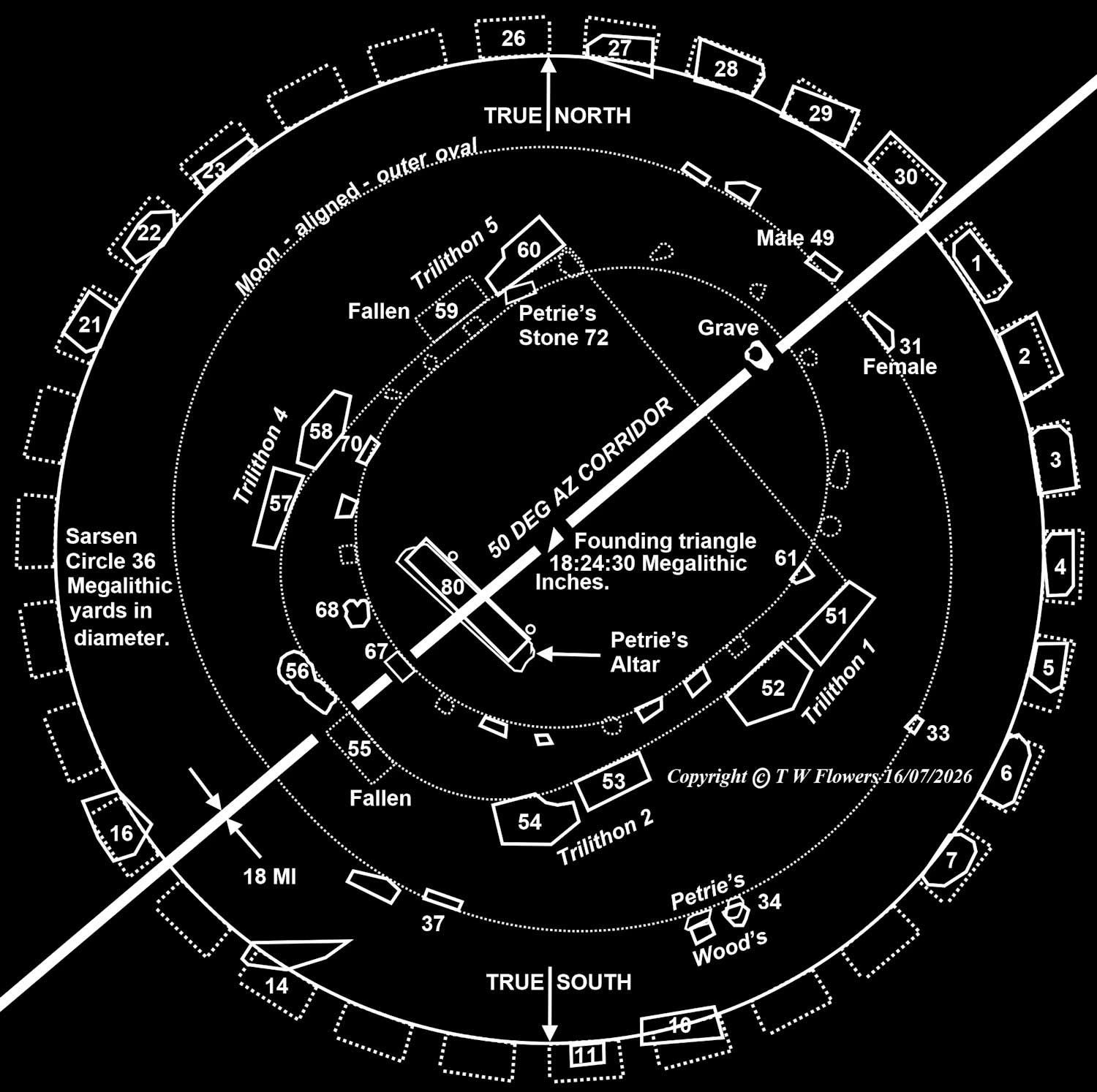
It’s also an internal device, with the sarsen stones of the outer circle arranged around a 36 megalithic yard diameter. (About 98 feet)
Stonehenge has two centres: the centre of the outer circle and the centre of the south-western arc of the inner oval (formally known as a horseshoe). These centres are 30 megalithic inches apart. This 30 MI distance allows a Pythagorean triangle with side lengths of 18, 24, and 30 megalithic inches, which produce a solstice corridor 18 megalithic inches wide, as at the nearby timber monument of Woodhenge.
Stonehenge was designed and built by the beaker people, who realised that a circle of 30 positions creates a corridor exactly 50-degrees from north. Again, like Woodhenge.
Placed on the north-western side of Stonehenge’s corridor lie Trilithons 3 and 4, the Inner Oval, the Altar Stone, and a largely forgotten, but dedicated inhumation.

SH3. This is a CAD version of John Wood’s ground plan of Stonehenge, which utilises all 800 of his original measurements.
Starting from position G, John traced his 10-sided polygon clockwise, creating a shape that failed to close by about 66 inches, or around two Megalithic yards. To reduce this error, we began at G, stopped halfway at M, then started again at G --- this time in a counterclockwise direction. This reduced the error to one Megalithic yard. You might just be able to see the one-Megalithic-yard kink, where we closed the shape, at M!
**********
With John Wood's measurements converted into Megalithic Yards, at the rate of one My equalling 32,664 imperial inches or 0.83 metres, let's decompose Stonehenge's sarsen and bluestone structure into its main components...

SH4. JOHN WOOD'S SARSEN AND BLUESTONE BUILDING SHOWING EVERY ONE OF HIS MEASUREMENTS AND TECHNIQUE. IMAGE PRODUCED ON CAD.
As a start, lets just consider the outer circle of sarsen stones.
This circle has its own axis - we call the 'Primary.' The circle forms a complete ring of 30 stones set around a 36 megalithic yard circle (98 feet).
With their inner faces facing the circle, stones 22 and 23 further support the conclusion that Stonehenge was an internal device.

SH5. THE BLUESTONE OVAL FORMALLY REGARDED AS CIRCULAR.
This oval consists of two 27-diameter circles with centres spaced two Megalithic Yards apart, and an axis aligned towards the Major Standstills of the Moon. These standstills are the northernmost moonset and the southernmost moonrise, similar to Stonehenge’s Station Stones. Note the Tiny 18:24:30 Pythagorean triangle in the centre.
Flinders Petrie's equally accurate survey shows bluestones 34 and 35 to be significantly closer to the oval than in John Wood's version shown here.
SH6. THE TRILITHON HORSESHOE.
An asymmetrical, heel-shaped arrangement of trilithons.
Trilithons 1, 2, and 5 are symmetrical about the Primary Axis of the Sarsen Circle, whereas the Great Trilithon and Trilithon 4 are aligned along what we will call the Secondary Axis.
We now show the original location of the Great Leaning Stone, Stone 56, which was levered upright and restored to its original place in 1901 by the mining engineer William Gowland.

SH7. THE INNER BLUESTONE OVAL.
Sir Flinders Petrie, the renowned Egyptologist, was the first to record the internal width of this oval as 14.5 megalithic yards, when it was still regarded as horseshoe-shaped. Like the Great Trilithon, this 18-megalithic-yard-long oval lies along the Secondary Axis. Further excavations in the 1960s confirmed its oval shape.
Petrie, while preparing his plan of Stonehenge, noted, "Even at this early stage, the Great Trilithon can be seen not to be on the solstice axis but to the west of it" (Petrie 1880).

SH8. The centre-point of Petrie's 14.5 diameter and the centre of the sarsen circle are 30 megalithic inches apart. This distance is the hypotenuse of a Pythagorean triangle measuring 18:24:30 megalithic inches. Stonehenge’s twin axes are separated by the 18-megalithic-inch perpendicular (14.7 imperial inches, 0.374 m). This triangle gives Stonehenge its eccentricity.
At 50 degrees clockwise from north, these axes are one degree short of the 49-degree Neolithic solstice. So Stonehenge is not simply an astronomical device but a geometric one, planned to the nearest 10 degrees.
This angular difference redirects the sun so it enters Stonehenge at a higher altitude, increasing its intensity.

SH9. A balsa model of Stonehenge - A view from the northeast along its twin axes.
To reiterate. Stonehenge features a pair of parallel axes oriented towards the summer solstice and spaced 18 megalithic inches apart. The primary axis pertains solely to the sarsen circle. The inner Bluestone Oval, previously known as a horseshoe, and the Great Trilithon have a separate axis, which we designate as secondary.
This model marks the position of an inhumation with a black circle, and it is the only inhumation dedicated to the stone structure. Located on the secondary axis, Col. Hawley unearthed this inhumation in 1920. Unfortunately, Hawley found that someone had tampered with the grave, mixing the individual's bones with debris.
Our model depicts what Stonehenge might have looked like after its construction, assuming it was ever completed. However, evidence suggests that building Stonehenge was a complex and challenging endeavour, leading some to speculate that it was never finished. This is supported by the unusually shaped and seemingly out-of-place stones that appear to have been added later, along with the peculiar arrangement of the Y and Z holes surrounding the sarsen circle (not shown), which seems to signify closure.
Stonehenge's twin axes are angled at 50 degrees clockwise from the north (Azimuth 50). This also applies to the straight section of the Avenue that leads from Stonehenge to 'Stonehenge Bottom' and the lowest point of the 'Stonehenge Great Cursus'.
When the striations in the Stonehenge Avenue reach Stonehenge Bottom, they veer 10 degrees east and cross the eastern end of the Great Cursus. After passing the Durrington Walls Henge, they head towards a convenient bend in the Avon where the massive sarsen stones, presumably coming from Westwood Heath, some 17 miles distance, might have alighted the Avon valley on their way to Stonehenge. Professor Gaffney of the University of Birmingham observed that these striations or deep ruts were present over much of this journey, especially as they approached Stonehenge. This indicates that the striations in the Avenue were caused not by glacial activity but by sarsen stones being dragged along it.
********
Nothing hindered the high-altitude summer solstice sunlight from reaching the centre of the sarsen circle and the Altar Stone. However, the same cannot be said for the winter solstice, which was obstructed by bluestone 67 when it was standing. Stone 67 was a formidable presence at Stonehenge, measuring thirteen feet long by a megalithic yard in width (33 inches) and standing eight feet tall. It was the tallest bluestone at the head of the “Inner Bluestone Oval” and was brought down when Stone 55 of the Great Trilithon fell upon it. This stone effectively obscured the 15-megalithic-inch gap (12 imperial inches) through the Great Trilithon. Therefore, while the rays of the winter sun passed through this gap, they were blocked by 67 and could not reach the centre of the sarsen structure.
Despite the assertions of leading archaeologists and an astronomer, the conclusion must be that ground plans indicate no one could have approached Stonehenge via the Avenue to witness the winter solstice sunrise. This is red herring diverted public attention from Stonehenge's true purpose while disregarding the fact that the winter solstice was obscured. Contradictory arguments, crafted to confuse the unwary, are prevalent in today's archaeological world.
The six megalithic, yard-long Altar Stone is likely skewed nine degrees from the axes of Stonehenge to reflect sunlight onto the “worked slim” Bluestone 49. This stone identifies Stonehenge as a male monument. Alongside its bulbous female counterpart, Stone 31, this pair welcomes solstice sunlight that enters through the 'Doorway’ between uprights one and thirty.
If you're seeking further evidence of the boy and girl stones argument, there's no better way than to visit the long barrow known as Wayland's Smithy, situated alongside the prehistoric Ridgeway a few miles south of Swindon. There, you can view an old photograph of the entrance to its chamber. The on-site photo depicts the boy and girl stones before Professor Atkinson's shabby reconstruction of the Smithy, which bears little resemblance to the original. You can also find this photograph on our companion website, AveburyDecoded.com.

SH10. Arminghall Henge is where people set up eight upright timber posts to demonstrate that the horizon could be divided into 36 equal segments. Disputed til now, Arminghall established the Stone Age 10-degree Rule.
Located less than two miles southeast of Norwich city centre in Norfolk, this hengiform monument has played a significant role in ensuring that the axis of Stonehenge points precisely 50 degrees clockwise from true north. The principles established at Arminghall were also adopted at Avebury, Woodhenge, and numerous other sites.
The inner ditch of the henge, once over two metres deep, is now completely levelled, but it is easy to identify due to the ring of nettles that has grown upon it. Unfortunately, a garden hedge obstructs the view to the south, where the sun and moon would set behind Chapel Hill. It is rather disheartening to consider the many natural views, once accessible to our Stone Age ancestors, that are now blocked. Some of these obstructions may well be intentional!
Some five years after its discovery, archaeologist G. Clark, through meticulous excavation, began to uncover the secrets of the Arminghall henge, but he found no evidence of a burial.
Arminghall was excavated once more in September 2022, possibly to challenge the Stone Age 10-degree rule proposed here.

SH11. Professionals attempted to establish an axis of symmetry for Arminghall's horseshoe-shaped timber cove but were unsuccessful. By consensus of opinion they wrongly agreed on an azimuth of 223 degrees.
Here, we propose an alternative solution.
Chapel Hill is located at the northern end of a larger landmass that extends southward to distant peaks visible from the henge. Two of these peaks create notches in the horizon that indicate where the southernmost sun and moon touch the ground when viewed from the henge. A third notch is 40 degrees (Azimuth 220), which marks the henge's axis of symmetry.
This monument further increases the likelihood that a German tribe, possibly the Michaelsburgers—those users of long-necked beakers—entered the country via Yarmouth and the river Yare. Unfortunately for them, the Rhine had changed its course, leaving their mountaintop retreat exposed and isolated from their agricultural land, making it difficult to tend to their crops. Consequently, they moved away and became lost to history.
The Arminghall monument featured posts with a diameter of one megalithic yard (32.664 inches or 0.83 meters), and each post stood at least five metres high. The posts were so large and heavy that they required long tapering ramps to assist with their erection. Once in place, they were likely topped with lintels for stability, as at Stonehenge. Like at Stanton Drew, six miles south of Bristol, the posts were burned to the ground.

SH12. Using paired timber posts, Arminghall's early geometer-astronomers accurately defined the cardinal points of the compass and established the ten-degree rule.
Since Arminghall's posts divide the compass into 10-degree segments, it is reasonable to assume that the primary alignment also follows this pattern of tens. Furthermore, a thorough study of the terrain confirms this!
These early scientists discovered that, regardless of where they lived—from John O'Groats to Land's End—the angle between north and east could form a right angle of 90 degrees, just as the other three-quarters of the compass did. The issue was that the sun and moon did not conform to these exact angles.

SH13. Chapel Hill Spur.
Due to a garden hedge south of Arminghall Henge, this photo was taken from closer to the spur and slightly off to one side of the monument's axis. Nevertheless, it provides us with all the necessary information.
Currently, a railway cutting runs through the centre of the spur. Approaching this cutting from the west (to the right in the photo), the rail is elevated to match its height. This is visible through a gap in the trees and beneath a rooftop. Unfortunately, the cutting prevents the winter solstice sun from reaching ground level and the River Yare. Regrettably, the railway authorities overlooked the significance of the monument when undertaking these actions.
Of even greater importance is a distant landmass beyond the spur that appears to the left of the peak of Chapel Hill. This landmass forms a notch toward which the monument's 220-azimuth axis points. This landmass is visible beyond the row of telegraph poles and through another gap in the treeline.
Although it is hard to see in this photograph, the bustling A47 crosses over the third landmass to the left of the Chapel Hill spur, which is where the southernmost setting moon will touch down during her major standstills in 2025/26.
*****
This is something I wrote and forgot about in my 2007 book, "Stonehenge Secrets." I apologise, but it is out of print. Perhaps more significant than Arminghall and certainly much larger, an array of 24 timber posts designed according to similar 10-degree principles was discovered near Norwich at Godmanchester. Presumably discovered during gravel extraction, Godmanchester and its cursus were dated to 3,800 BC. I hope to follow up on Godmanchester one day, especially if I can obtain its coordinates from the authorities.
Meanwhile, consider this essential fact: Stonehenge is an internal device.
Quote: "The main concern of the builders was to produce a presentable finish on those surfaces which would be seen from the interior of the site - the exception being the great trilithon." Stonehenge, Page 121. Atkinson R, 1956.
Avebury is an internal device, too…
Quote: "I observed further that as these stones generally have a rough and a smoother side, they took care to place the most sightly side of the stone inward, towards the included area." "Avebury, a Temple to the British Druids. W. Stukeley. 1727.”

14. Castle Rigg Stone Egg, Cumbria.
The Stone Circle at Castle Rigg, Cumbria, is a beautiful structure. Its alignment with a distinct notch and the most northerly setting moon during a major standstill is significant. Additionally, its axis points towards the 715-meter-high peak of Lonscale Fell, beyond the River Greta that feeds into Derwent Water, highlighting the importance of its orientation.
It might be a surprise to learn that Stonehenge has been explained using just one diagram and two paragraphs of text on a single page. And that diagram is not of Stonehenge! That page has been hidden elsewhere on this site. Everything else you might learn about Stonehenge, including what you see on TV and read in books, magazines, and newspapers, is nothing more than red herrings thrown in to mislead you! Misdirection is widespread in the world of Stonehenge!
Every day brings a new Stonehenge hypothesis, and someone proves a hypothesis wrong every other day. That is why early archaeologists and antiquarians had the professionalism not to speculate. But sadly, those professionals have long since gone.
Not so long ago, the late Professor Wainwright - once head of the British Antiquarian Society of London - presented programmes on TV and other media to convince us that Stonehenge was a place of healing like Lourdes of France. Thankfully, Wainwright's idea faded away in a matter of a few short months. Another speculation is that the massive Durrington Walls Henge lies in an area of the living, and the region around Stonehenge is reserved for the dead.
Where did archaeologists get this idea from? Did it come from another professor - a member of the Time Team, perhaps, or did it come from a learned member of the Open University? Or did it come from a vote taken along the lines of what archaeologists call a 'consensus?’ No, our best brains aren't knowledgeable enough to produce an answer for Stonehenge alone, so their latest offering comes from as far away as Madagascar and a megalith builder called Ramilsonina.
Archaeologists might as well have gone to the moon!
Yet again, another theory returns to the original belief that Stonehenge was a Temple. Another archaeologist, who has obviously read my work, has suggested that the Stonehenge site was a cradle! -- And he is close to the mark!
Stonehenge had only one purpose, and it is the one that is presented here. It’s also the only hypothesis that professionals will not listen to!
They don't seem to mind discussing things like Ley-lines, water divining (supposedly looking for underground springs), penetration of Stonehenge by phallic shadows, alien visits from Mars, a hospital, for the noise it makes when its stones are struck or when drums are played inside it. So, why should they fear airing the hypothesis disclosed here? It’s simply because this fearful hypothesis is correct.
*****
Maud Cunnington, the excavator of Woodhenge, took time off in 1928 to view Stonehenge's Aubrey holes while left open for viewing by Col. Hawley. This is what she thought of them…
"The Aubrey holes are fairly circular, whereas the bluestones are flat and angular. Is any other case known where prehistoric builders made round holes for rectangular stones? In the other holes at Stonehenge and Avebury, the holes conform closely to the upright. Moreover, the cremations were not found at the bottom of the Aubrey Holes but down the sides with silting occurring as the timber posts decayed."
"Woodhenge: a description of the site revealed by excavations carried out by Mr. and Ms. B. H. Cunnington 1926-7-8."
Timber posts were placed in the Aubrey Holes 5,000 years ago. The first pair, numbers 28 and 56, fixed Stonehenge's axis at 50 degrees.
Woodhenge is egg-shaped, with its axis aligned with the northernmost rising moon. This indicates knowledge and utilisation of the moon's 18.61-year Major Standstills. Like Stonehenge, a corridor allows 50-degree high-elevation sunlight to enter for fertilisation. This challenges all traditional Stonehenge hypotheses. As a result, this hypothesis has been silenced by those in power. The same thing happened in 1967 when Professor Alexander Thom called Woodhenge an egg. This is an extraordinary cover-up of our times.
A full report on the moon egg known as Woodhenge will be presented to you later, and you can click through and read it immediately. But I hope not. Instead, I hope you stay awhile and thoroughly read this work to understand what Stonehenge was really all about.
****
Sunrise from my east-facing bedroom window on Tuesday morning, September 7th 2021, was a revelation. Forecasters had predicted a heatwave for that day and were not wrong. There was not the faintest trace of a cloud in a clear blue sky, and the orb of the newly risen sun shone bright red through the earth's atmosphere with rare clarity. However, a few minutes later, the situation changed dramatically. The sun blazed brilliant white and was dangerous to look at.
So, while our parents warn us as children not to look at the sun, you can tell from the solstice photograph above that it is relatively safe when viewed over a low-altitude horizon. Thousands of visitors to Stonehenge do so every year.
To reiterate. Picture 1 proves that Stonehenge is not aimed at the actual solstice - not at the first glint, the half orb, or even the entire sphere, but when at much greater power well clear of the ground. The same applies to the nearby Woodhenge, Durrington Walls, Avebury's South Street long barrow and Beckhampton Cove.
This article should also be a warning to anyone who fancies researching Stonehenge. It's already solved, so don't risk your eyesight for it!

13. Castle Rigg Stone Circle, Cumbria. Surveyed by Professor Alexander Thom. "Megalithic Sites In Britain," page 150, Oxford University Press, 1967.
Professor Thom's manipulation of his many surveys was designed to hinder the progress of Stonehenge research. Furthermore, archaeologists are permitting these obstructions to keep Stonehenge as a profitable mystery.
Professor Thom was a fine engineer and surveyor who allowed himself to become corrupt to please archaeologists. Professor Thom knew that stone circles were internal devices and did nothing about it. So, while his ground plans are accurate, like this one, his suggested profiles, which pass through the centre of the stones and not their inside faces, are incorrect.
What is more, he did not resolve the Megalithic Yard this way.

14. CASTLE RIGG RESOLVED.
Through meticulously highlighting standing stones and carefully disregarding the displaced and fallen, we can confidently assert that Castle Rigg is a geometric egg, not a flatted circle, as Thom claimed.
This geometric egg comprises three arcs and a blend radius - a type-style reminiscent of the outer rings of Durrington Walls’ Southern Circle - Stonehenge's neighbour, Woodhenge - and the solitary egg of Scottish Callanish 1.

SH14. The Stonehenge hypothesis.
At its core, Stonehenge was a product of human curiosity. The idea sprouted from the notion that sunlight could be reflected off stones, potentially highlighting the moon. This intriguing concept originated 18 miles north of Stonehenge at Avebury, the assumed source of Stonehenge's sarsen stones.
The Beaker people's ideas extended even further. They constructed a complex timber monument comprising six eggs, reminiscent of ‘Russian eggs’, situated a short distance south of the Durrington Walls henge, with the outer four eggs aligned with the northernmost moonrise. This egg was designed to be fertilised by summer solstice sunlight and the spirit of a four-year-old girl buried at its centre.
Fascinated by the achievements of the people at Avebury, the Stonehengers (now known to be the Beaker People) considered the possibility of placing not just one, but thirty megaliths in a circle and reflecting high-intensity sunlight around their inner surfaces.
The builders of Stonehenge and Woodhenge harboured a deep hope that their creations would come to life through their dedications, alignments with the sun and moon, and the mother womb of Durrington Walls, which used the River Avon as an umbilical.
Furthermore, if we accept that Woodhenge was a moon egg meant to be fertilised by the sun, then we can interpret this as evidence supporting the hypothesis that Stonehenge was a baby sun.
The circles and eggs of wood and stone were ancient people's attempts to achieve an everlasting summer. The idea of perpetual sunlight seemed to offer Britain's first farmers the opportunity to cultivate their crops year-round and enjoy life to the fullest.
As we celebrate, I want to thank the AI-powered Grammarly app. This website would have been a struggle without its support in enhancing my grammar. Still ongoing!

SH15. Picture taken 3rd July 2016.
There is a good reason why the flattest face of the Heel Stone aims towards the northernmost moonrise. This alignment crosses over Stonehenge's axes and the incoming solstice, effectively combining the sun, the moon, and Stonehenge into a single, unified entity.
Note also how sunlight at low altitude illuminates every stone, and compare this with Avebury's Cove, where Stone Age folks first employed this phenomenon!
A brass plaque, recently installed by English Heritage and embedded in the grass, was impossible to accurately place without prior knowledge and agreement with the sarsen circle's centre and its diameter of precisely 36 Megalithic yards. It also proves acceptance of the Stone Age 10-degree rule.
This axis is shown in red. The aqua line marks the secondary axis, which passes centrally through the gap of the Great Trilithon. These axes are eighteen Megalithic inches apart (14.7 imperial inches).
The Beaker people's geometry is highly precise, and they alone were responsible for designing the final sarsen and bluestone structure at the centre of Stonehenge.
The Heel Stone's alignment. This revered and distinctive stone stands within a circular ditch filled with bluestone fragments, emphasising its importance. John Wood's survey shows that its front face is aimed 40 degrees clockwise from north and therefore towards the northernmost moonrise. The northernmost moonrise occurs every 18,61 years during the Major Standstill, some 10 degrees further north than the solstice.
The Major Standstills are the moon's extreme northernmost and southernmost moonrises and moonsets. These give the four Lunastices, and like the solstices, there are four of them. Northernmost moonrise and set, and Southernmost moonrise and set.
The last time these events took place was in 2005/2006, and was an opportunity missed. The Major Standstill is currently upon us, offering a unique opportunity to observe these celestial phenomena.
English Heritage hopes, or so they say, to livestream the southernmost moonrise, visible across the four Station Stones forming a rectangle outside the sarsen circle. Some hopes! They did not turn up for the the northernmost moonrise at Woodhenge. EH have no love for Stonehenge and cannot see beyond the pound note!
Woodhenge, more than any other monument, proves the Stonehenge hypothesis. That is where English Heritage should have mounted their cameras and equipment. I was there on the 11th of September at nine o'clock at night, 2025, and with an absolutely clear sky, witnessed this wonderful event as the Beaker People did.
And where were the Druids? Where were archaeologists? Where was English Heritage? Where was the Society of Antiquarians of London? Where was the Open University? Where was just one member of Wessex Archaeology, located a few miles south of Woodhenge, sent to witness this once-in-a-19-year event? Where was Oxford University? Their engineering department is named after Professor Alexander Thom. And it was Thom who called Woodhenge an Egg in the 1960s.
I was on my own. I'm the only person in the whole wide world who witnessed the wonder of the Beaker People and nature. The Major Standstill moon rising inline with Woodhenge.
Little did I realise, though, that my camera's battery was flat. Or, were my pictures deleted by a malicious force wielding the sort of device that common criminals use to open car doors and drive away with them?
As for Stonehenge, English Heritage's live stream should have been a scientific endeavour to show that the long sides of the Station Stones rectangle, now believed to be a single triangle, align precisely with the southernmost moonrise in one direction and the northernmost moonset in the other. For further details on the station stone rectangle/triangle, please refer to the section 'Stonehenge Geometry.'
In our quest for evidence supporting our Stonehenge hypothesis, we will continue exploring ways to bring the sun, the moon, and a star — or stars — together at a single location.
There was something else I noticed during my recent visit to Woodhenge. Alexander Thom's datum post, from which he conducted his 1960s survey, has been removed. This will prevent anyone from reproducing his survey ever again. Also, the on-site information board continues to wrongly state that Woodhenge is aligned with the sun.

SH16. STONEHENGE'S AXES. YES, THERE ARE TWO OF THEM!
Five thousand five hundred cold winters and a Stone Age wish for a perpetual summer, a wish that seems more distant now with the onset of global warming, a phenomenon that threatens to disrupt the delicate balance of nature.
Britain’s first farmers, living in south England, treated Wiltshire’s extensive Chalk Massive like a vast whiteboard to scribe their designs. That is how Stonehenge started, just three circles of pure white chalk appearing through the lush green grass. The circles were complete except for two causeways, the most extensive pointing northeast towards the most northerly risings of the sun and moon. The centre-point of those circles was chosen for one main reason.
This reason is well known, and several authors have already written about it. Stonehenge stands at latitude 51, where the sun and moon have an angle of 90 degrees. So, Stonehenge started life by obeying the Stone Age 10-degree rule.
*****
So, a piece of high ground, a mile to the northeast of Stonehenge, to what is known today as Larkhill, was recognised as a suitable place for more timber posts to track the moon and further establish its northernmost position. This turning point, not unlike a terminus, occurs every 18.61 years. However, while this 18.61-year event is accurate enough, it is not dead on, and the Stonehengers knew it. Hence, fifty-four more posts were placed in a circle to represent the 56-year frequency of the moon - the time it takes for the moon to return to the same place from where it started. Of course, even this is not absolutely accurate, but never mind! Because we now have a fabulous piece of theatre designed to bring the sun, the moon, and the top-most star of the Southern Cross - the red Gamma Crucis - which was still visible from Wiltshire 5,000 years ago - together in one place.
*****
Here are a couple of quotes from the book Stonehenge Decoded...
"I set up my eight-millimetre movie camera with telephoto lens trained down the axis line to include in its field the sarsen circle archway through which the distant heel stone could be seen. We waited. Suddenly, in the band of brightness to the northeast, we saw it - the first red flash of the sun, rising just over the tip of the heel stone!" Gerald S Hawkins, Stonehenge Decoded, P 93.
Two points to be made here are... First, Hawkins believed that Stonehenge's primary axis passes centrally through the gap of the Great Trilithon. It does not. Consequently, his camera was not placed on Stonehenge's primary axis. Furthermore, the sun does not rise "just over the tip of the Heel stone" on summer solstice morning.
Quote 2. "We had deliberately planned our visit for June 12, nine days before the solstice, because we feared that on the day itself, the crowd would make it impossible to set up a camera on the correct alignment and have an unobstructed view.
"Stonehenge Decoded,” Page 92.
The problem of crowds getting in the way and making it impossible to place a camera on Stonehenge's axis still applies today! Also, the sun passes 'just over the tip' of the Heel Stone twice in June... not on solstice morning, but about five days before and five days after!
*****
Here, we hope to convince the reader that Stonehenge was built by people who believed the sun to be male, the moon to be female, and the stars to be potential children. This alone should tell you what Stonehenge was meant to be.
*****
This site deals with everything our ancestors got up to that made them think they might have a way of guaranteeing them the three essentials of life - Food, water, and heat. They could grow food as staples, and water was plentiful. But they needed a second sun to warm them in winter and to grow out-of-season crops. It was not that difficult. -- Or so they thought.
As the tale goes, a group of curious minds embarked on a project to build a sun simulator using 450 tree trunks arranged in nine ever-expanding circles at Stanton Drew. However, when they set it alight, it failed to generate the expected heat. This led them to question whether the sun could be made of stone? But then, how could they make stones burn? And more intriguingly, how could they make it fly? These were just a few of the captivating challenges they faced!
*****
As mentioned above, Picture 1 was taken while standing in the middle of Stonehenge’s solstice doorway between pillars 1 and 30 - "The Grand Entrance" - as William Stukeley called it. The photo shows how the sun has surpassed Stonehenge's axes by some distance to the north. According to the astronomer the late Professor John North, the first flash of the sun in 2,500 BC was 48.5 degrees clockwise from the north - a full 1.5 degrees past Stonehenge's axis. It was further north still in 3,000 BC when Stonehenge was started!
I couldn't understand why the sun in Picture 1 appeared so far to the left of the Heel stone, so I reached out to Wessex Archaeology to ask for an explanation. That was at least ten years ago, and I now understand why. Stonehenge is not perfectly aligned on the solstices, neither in the summer nor the winter.
The sarsen and bluestone building, with its best faces of stones dressed and pointing inward, was designed to capture and trap sunlight. The builders intended to illuminate the entire Stonehenge, much like the sun lights up the Backstone of Avebury's Cove - as shown in a later photo. This leaves us wondering - did they know they were using techniques similar to modern-day LASER technology?
Picture 1 also shows how the moon travels about 10 degrees further north than the sun. So, the sun goes nowhere where the moon has not already been.
Cremated human bones were fetched from pyres lit alongside the Durrington Walls timber-built Southern Circle exit and placed alongside the fifty-six timber posts in the Aubrey Holes. The Stonehengers believed that cremation released the spirits of the dead. And, by burying those spirits inside Durrington Walls’s Midden,' yet taking the bones to Stonehenge - those spirits would have to travel the Avon umbilical to join them!
The West Amesbury Henge, dubbed “Bluestone henge,” having circular post holes, was a timber henge, not stone. We will call it "The West Amesbury Timber Henge."
This henge, built on the bank of the river Avon, marks the start of the avenue that takes the spirits of the dead overland via Stonehenge Avenue to Stonehenge. This circle of some twenty timbers measures 12 megalithic yards. So, The West Amesbury Timber Henge was one-third the size of Stonehenge. This size, together with the increasing radii of the large curve in Stonehenge Avenue, is further proof of a wish for Stonehenge to grow.
The largest radius in the bend of Stonehenge Avenue scales to 750 megalithic yards. This radius can also be found at Durrington Walls, Avebury, and Windmill Hill.
Caution! The following paragraph was written before the war in Ukraine and the destruction of the Nord Stream 2 gas pipeline and is not meant to upset anyone.
The only hypothesis that fits all the known facts is a prehistoric wish to give birth to a baby sun.
Those who dispute it should spend a killer winter outside without the benefits of gas fires to keep warm and electric lights with which to read a book and light their way. And if that is not enough, try growing out-of-season wheat, barley, and vegetables. Or try picking crab apples, blackberries, and hazelnuts, long-rotted and fallen off the trees.
The following story is my attempt to become a novelist. I will not be offended if you avoid it and click the button on the right, which will take you to Home Cont'd. Thank you.
*********
This story begins on a sunny spring morning many years ago, when a Stone Age farmer named Brennos was seen busily preparing a patch of land to sow barley seed for a harvest he desperately hoped to get.
Controlling the plough, harnessed to a pair of robust oxen, was no easy task for Brennos. The leather twine that held the contraption together often snapped, causing the entire device to collapse. Despite the tediousness of the repairs, Brennos diligently reassembled the plough and pressed on with his work.
As Brennos surveyed the fine soil, which he had prepared he couldn't help but feel a sense of pride. The bumper crop from the previous year was a testament to his family's hard work. They were always by his side, busily engaged with sowing seeds for the harvest they hoped they might get.
This was in 3,500 BC. The place? The Kennet Valley, which would one day become the Kingdom of Wessex.
Brennos had many friends who preferred to trap prey to feed their families, which was no bad thing. Combined with Brennos's ability to grow wheat, barley, beans, and peas, his family usually managed to maintain a well-balanced diet. Even so, Brennos’s friends still marvelled over his abilities as a farmer.
Brennos understood only too well what they meant. Some years, if the weather were cold, his crops would likely fail. And if it were unseasonably wet at harvest time, his produce would rot in the ground. Brennos was not saved from the constant worry of keeping his seed in good condition for the following year's crop. If it had not been for the sun that travelled far to the south every winter, he would not have had this problem, and the ripe seed would have been available for immediate sowing.
Brennos stopped awhile to consider the work they had done that day. The oxen had drawn the plough, turning the field into regimented lines of shallow furrows; his wife had placed seeds upon the bottom, and his children had sprinkled fine soil to cover them. Together, they had covered about half an acre during the day. Not a bad day's work, Brennos thought, and he hoped the sun and rain would be kind to his family by bring them a rich and plentiful harvest.
Brennos unfastened the plough as the sun set and led the oxen back to their pens, affectionately stroking each animal's bony head. Navigating their way home in the dark was perilous, so Brennos and his family banded together closely, with his son bringing up the rear and carrying a torch to deter any wild beasts that might attack them.
Sometimes, the moon offered some light, but on this cloudy night, there was no such luck. Fortunately, one of Brennos' colleagues had built a fire, which they tended to frequently to help guide them through the trenches surrounding their hilltop abode. Upon arrival, they were welcomed with a feast of bread, cheese, and warm goat's milk to wash it down.
Gazing into the flickering flames of the fire, Brennos couldn't help but feel a tinge of sadness as he remembered the many friends he had lost during the previous winter. It wasn't a particularly harsh winter, but a mysterious illness had spread throughout the area and had claimed the lives of the weaker individuals.
To raise his spirits, Brennos' friends shared jokes and stories while others recounted tales from their folklore.
Later that night, the clouds that had been blanketing the sky began to clear, allowing the moon to peer down on Brennos’ group as they huddled around the fire below her. And as usual, Brennos's friends tried to explain what the moon was.
Brennos noted how the moon and his wife passed through monthly cycles, year after year. This convinced him that the moon was female too. The whole group was aware of the changes in the moon's shape as she waxed and waned from a 'C' to a 'D' to an 'O' and back again.
To Brennos, the moon was a live person; he could see she had a face that never seemed to smile. Strange, Brennos thought, how she was forever avoiding the sun. Sometimes, she would appear during the day, but not until she had made herself invisible to him, for she was so utterly shy. She seemed to want to keep as far from the sun as possible. If only I could bring the sun and moon together, Brennos thought. They might get to like one another. She might even conceive a child.
Brennos was brought back to reality by one of his friends who noticed him looking up into the sky, as he often did. This friend suggested they might build a massive mound of significant length (A long barrow) complete with a portal and chambers at one end to catch equinoctial sunlight and moonlight and as somewhere to inter their deceased colleagues.
They knew of a pleasant place with a commanding view on the other side of the Kennet Valley, and everyone agreed to build the mound there. Who knows what might happen?
They also decided it would be better to construct the chambers from some enormous stones if only they could find some way of moving them. Brennos doubted whether such large stones could be moved; they were so big, but everyone decided to try.
First, they gained experience by moving the medium-sized ones around by turning them into rollers clad in wood. This effectively turned them into giant wheels. Then other folks went to the strangely named hilltops of Overton and Fyfield Downs, where they could find the choicest and best shapes. Then, milling around the largest, they looked under and around them.
Some stones exceeded twenty tonnes in weight, and the transportation of just one of them, having to cross a river and drag it up a hill, was an enormous task.
Some of Brennos’s group chopped down some trees and stripped them of their branches and bark, thus turning them into long wooden posts. Then, using these large posts as levers, with small stones for fulcrums, they released the megaliths from their beds and dragged them to the site.
First, they built the walls to make five small rooms, each one branching off from a central entrance passageway. Next, they excavated the chalk from a pair of ditches on each side of the mound and used it to make it still higher.
Then, they laid massive capping stones across the top to form the roof. Finally, more chalk was taken from the ditches until the whole structure was a gleaming white 330-foot-long trapezium set against a pea-green landscape.
Brennos held a lighted brand against one wall to demonstrate to his friends how sarsen stones reflect light. "Imagine, he said, what might happen when sunshine and moonlight enter the tomb. It might even bring their friends back to life.
Brennos and his friends were justifiably proud of the Long Barrow they had built and oversaw the building of several more.
Many years later, the portal of this long barrow was sealed up with large blocking stones after receiving a murdered beaker man, together with his fashionable lozenge-decorated beaker. This accurately dates the event to around 2500 BC. Monuments such as this mound, or tumulus, known as ‘The West Kennet Long Barrow,’ were decommissioned by command. Perhaps the murdered beaker man, found with an arrow in his back, disagreed!
Brennos and his family continued to plough and sow the land to ensure the success of their crops. How well everything grows, Brennos thought, when the sun is shining, life is so much better in the summertime. He wished he could have two harvests a year instead of just one. Then, he could provide food all year without worrying about storing seeds and risking them rotting away every winter. He so wished that the sun could be with him all year round.
Brennos held a few grains of barley in the palm of his hand. Within these seeds, he knew, was the very essence of life, and he realised why he had chosen to be a farmer. He also knew that he only had to bury these seeds a little below the soil's surface, where they were kept warm and sheltered for a while, and the spark of life would begin.
Brennos wondered where the sun came from. It emerged from the ground in various places, stony ground too, but no one had ever discovered any holes from where it emerged. Brennos knew that the sun did not need a hole to emerge from and was, without a doubt, capable of passing through anything. Equally clear was that the sun travelled underground during the night and probably stayed beneath the knolls of Britain, of which Brennos knew several.
The rain also puzzled Brennos because it fell from the smoke that the sun made in the sky. This made him wonder if rain, too, emerged from the ground. He knew some folks who had dug deep pits, hoping to find the sun, but had discovered a water source instead. Others had found choice flint and were in the process of mining it.
Brennos reflected upon their folklore that told of when his ancestors had tried to simulate the sun. It was said that they had cut down hundreds of large trees and turned their trunks into posts to describe a succession of ever-increasing circles. This giant structure was more than three hundred feet in diameter by six men high. Then, according to this legend, they had infilled the gaps between the posts with lots of combustible material and set the whole thing alight.
This legend is based on fact. About 6,000 years ago, a large assembly of over four hundred massive timber posts that radiated outwards in ever-increasing circles was built at Stanton Drew. - See report later. Magnetometry readings taken a few years ago proved that this circle of tree trunks was subsequently burnt to the ground. Sometime later, this massive fire was superseded by a henge and Britain's second-largest stone circle.
Brennos often pondered if the legend was true. Each post must have weighed about the same as thirty-five men and would have stood in a hole the height of a man.
With arm outstretched, Brennos tried to gauge the sun for size. His thumbnail completely covered the sun disc and was six times larger, so he thought the sun was not very big. He also realised that it could not be reached from the top of Waden Hill, so it had to be larger than this. Brennos could also see that the sun was higher than the clouds, which Brennos thought was smoke produced by the sun, which hung around in the sky.
After considering the problem at length, Brennos decided that the sun was a disc, or sphere, of about 1500 megalithic yards in diameter (4,083 feet), and it had somehow become self-sustaining.
Please press the NEBRA button at the top of this text.