
SD1. John Wood senior was the first to recognise an alignment on the southernmost moonset around 1720 AD. He considered this to be between the North-East circle and the South-South-West Circle. That is why he called the North-East Circle a Lunar Temple.
This plan of Stanton Drew's shallow valley lies about six miles south of Bristol towncentre and shows the locations of its three stone circles and stone cove. This is where the Sun and Moon come face to face with Pythagorean geometry.
Early people used the underlating landscape at Stanton Drew in a similar way to how the Beaker People treated the Durrington Walls henge, near Stonehenge, to create a play on altitudes.
Stanton Drew Alignment A is interesting because it runs from southwest to northeast at an angle of 53 degrees clockwise from north to closely match the acute angle of a 3:4:5 carpenter's triangle. These early landscape surveyors understood only too well the effect of altitude on the solstice and lunar standstills.
What better place could there be to manufacture a synthetic sun of timber beneath this 53-degree line?

SD2. A photo of the summer sunrise and John Woods’ “Lunar Temple”, taken from near the centre of the Great Circle.
Walking the line...
The altitude measured from the centre of the NE Circle is 1.36 degrees,
Update 1st June 2026.
It seems there is only one place where the solstice coincides with Stantons main alignment and its been known for many years. Consider this from Sir Norman Lockyer 1906:
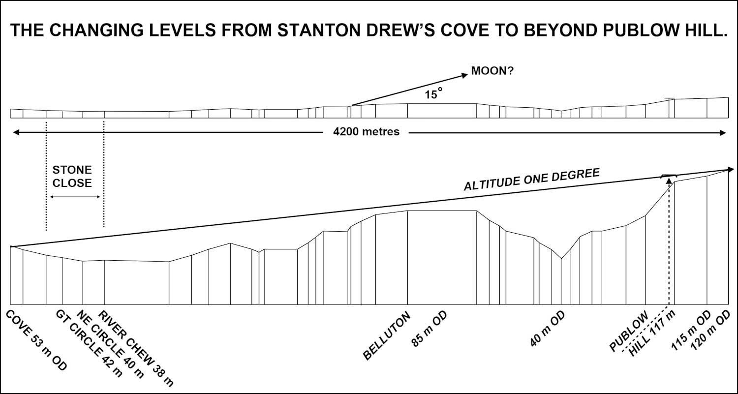
SD3. Stanton Drew levels. The top image is to scale: The bottom image is exaggerated vertically.

SD4. Northernmost sunrise with the sun rising out of Publow Hill. Altitude one degree, seen from the South-south-west Circle on the 19th of June 2016.
It was on the evening of the 18th of June 2016 that the weather forecast for the following day promised a cloudless sky over the Bristol area, in an otherwise overcast Britain. This clearing presented a photographic opportunity too good to miss. So I packed a lunch, brewed a flask of tea, and with cameras packed away in the car's boot, I set off to spend the night at Stanton Drew.
The village of Stanton Drew has only one public house - the excellent and highly recommended Druid’s Inn. This inn has a spacious car park to one side, from which I planned to conduct operations and where I could get some overnight shuteye. The car park is on two levels, and the upper level leads to a prominence where prehistoric folk chose to build a stone Cove.
The Cove sits on Alignment A, from which Stanton's early inhabitants had a clear view towards what is now Belluton and beyond. Another purpose of the Cove was to receive the southernmost rising moon and the star Gamma Crucis, which disappeared below the southern horizon around 4,800 years ago.
********
We began by taking a photograph of the summer solstice from the South-southwest Circle, as shown above. The photo proves little, but we were surprised that a walk from here to the Great Circle gave a second chance to observe the dawn. WOW.
It's all to do with altitude.

SD5. We are using the previous photo to explain how in certain curcumstanes a screen could block out the solstice sun, causing the moon to take its place. It does not matter what the screen is made of; it could be a brick wall or the side of a mountain. The important point is that it requires the viewer to look over it at about 13 degrees. Under such conditions, or similar ones, the moon can take the place of the sun during a Lunistice when it is dark and cloudless.
The story begins with someone standing where the Cove is now, looking northeast across the River Chew and beyond to a distant peak, and realising they had the ideal conditions for a grand plan.
Repesenting Mother, Father, and child in the minds of Stone Age man, a 4 : 5 : 3- sided triangle was produced alongside the Cove, over the ground where the graveyard is now, with its hypotenuse marking one end of the four-kilometre-long Alignment A.

SD6. From sleepy brook to deep ravine.
It's said that the stones of Stanton Drew walk down to the river Chew at night to take a drink. So I took a look at this river, and I can say that any stone that took a drink from it never came back! With steep slopes on either side, the river resembles a miniature version of America's Grand Canyon.
The idea is as daft as believing that men and women constructed stone circles so they could sit and stare at the sun. taking stupid risks with their eyesight.
I estimate this ravine to be about four metres deep and seven metres wide at the top.
%20produced%20230920.jpg/:/)
SD7. Another archaeological red herring! I see no alignment suggested by Professor Thom.
A view from the centre of the Northeastern Circle.
Alignment A passes through the centre of the Great Circle and ends at the Cove, which lies hidden behind the church. Its centre is conveniently marked by a group of visitors there to pay their respects. This photo shows that the sun is too far south to be aligned on the winter solstice when viewed from the North Circle.

SD8. A view looking down on Stony Close from the South-southwest Circle.
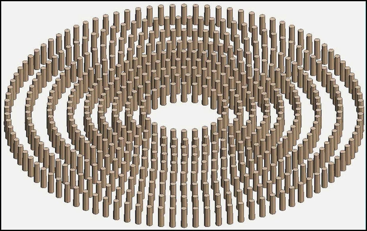
Although most of its stones are missing, this picture shows how the Great Circle and its henge looked four thousand five hundred years ago. However, this is not how the Great Circle began. It began as a massive 300-foot-diameter fire that replicated the Sun.
Also visible in this picture is the more complete North Circle, conveniently framed by the causeway through the Great Circle's bank and ditch. John Wood called the North Circle a "Lunar Temple" because he believed a line between it and the South Circle points to the southernmost moonset.
It also pointed to low-traversing stars, such as the slowly disappearing Gamma Crucis of the Southern Cross, which dipped below the southern horizon around 5,000 years ago due to the precession of the Earth's axis. Imagine how the inhabitants of Stanton Drew felt, watching those stars slowly disappear!
S
SD9. Mankind's early attempt to replicate the sun. This colossus was 135 megalithic yards in diameter (122.5 yards or 112 m) and was constructed from oak tree trunks. Discovered in 1997 by English Heritage using a caesium vapour magnetometer, the nine timber circles were deliberately set on fire.

SD10. This is what the fire looked like from the South Circle.

SD11. A view south from Hautvilles Quoit.
This alignment from the Quoit -- a solitary standing stone -- passes through the centres of the Great and South circles, keeping watch on the slowly disappearing stars of the Southern Cross. The line is acknowledged to be not quite straight, as you might expect when tracing the position of a star constantly on the move.

SD12. No doubt encouraged by archaeologists who cast doubt on the Tyning Stones' connection to Stanton Drew's stone circles and Close, despite the stones marking the equinox and the location of a freshwater spring that feeds into the Chew.
This derogatory attitude no doubt encouraged a farmer to pull them out of the ground and carry them off to build a bridge over the Chew upstream of the Close.
This photo shows how the Tyning Stones ended up. One has been broken into handy-sized pieces to support its partner.
The original position of the Tyning's is still marked on OS maps, which show an alignment with the Equinox when viewed from the centre of the North Circle. This alignment extends for some seven miles, ending at the high plateau on which Bristol Airport is built.

SD13. Stanton Drew's Cove.
Some archaeologists believe the Cove may once have been the portal of a long barrow whose mound disappeared long ago. They also suggest that a long barrow would make the Cove 1,000 years older than the stone circles. I don't believe that the Cove was once part of a long barrow - It's more likely where our early surveyors marked out an accurate north-south line as part of their triangle.
The side slabs of the Cove are not parallel, like Aveburys Cove, but have a definite outwards splay. To determine precisely what these stone point at, it was necessary to measure their angles and decide, as closely as possible, what each slab aims at. To this end, a wooden contraption was constructed along the lines of a parallelogram. This device helped to show that the side slabs have a splay of about nine degrees.
Determining what each slab points at was another problem. As you can see from the above, the view south (or southeast) is often blocked in summer by bushes that spoil the view.
Fortunately, I already have some photos on file, taken in winter.

SD14. And this is the result. Previously thought to face too far south to align with anything important, Stanton's Cove was intended to bring the moon and at least one of the fast-disappearing stars of the Southern Cross together with Alignment A. Bringing the Sun, Moon and stars together in one place for copulation, is what the Stone Age was all about. Most likely date of Cove is 3,300 BC.

SD15. HERE IS THE REAL THING. Seen from Stanton Drew's Cove.
This photo of the rising moon was taken on 12th March 2026 at around 4:30 in the morning.
It is a photo of the southernmost rising moon at Lunistice, struggling to pierce through thick clouds. With greatly increased contrast, it won’t win any photography awards.
But it does prove that the four-kilometre long, Alignment A is equally valid as a moon-entity.
This provides further evidence for recognising Avebury's West Kennet Avenue of paired stones as a moon entity, which we already acknowledge.