
80. The much-derided Beaker people, often overlooked in archaeology, were the masterminds behind the architectural marvels of the Durrington Walls henge and timber circles and even Stonehenge. Their designs were not mere structures, but a testament to their profound understanding of celestial alignments and intricate rituals. They showcased a keen awareness of how altitude influenced these alignments, particularly when observing the mid-June sunset vanish behind the distant rim of Durrington’s bowl-shaped valley from a bend in the River Avon. This elevated perspective shifted the sunset 10 degrees further south than at Stonehenge - a significant deviation.
The brilliance of this sunset was far more intense, a spectacle that only occurred on summer solstice eve. However, the modern landscape, including the Countess Road, has unfortunately obscured this view.
The Avenue is not aligned on the winter solstice, as Professor Pearson says; the horizon to the southeast isn't high enough to modify the sun the full 10 degrees needed to align it with its azimuths of 120 and 300 degrees.
Ashes from a cremation between the ‘cervix’ and the egg were transferred to an area known as a ‘Midden’ enriched with beaker sherds adjacent to the egg. However, people's bones had been carefully sifted out and taken to be buried in the Aubrey Holes of Stonehenge. This left some very restless spirits behind – as was the intention.
Mention must be made of this henges numerous radii based on Avebury’s 750 MY moon antenna that the beaker folk built into it to give credence to growth symbolism.
In mid-June, sunlight entered the timber egg, known as the Southern Circle, to act as a fertilising agent. However, its progress was restricted and contained by numerous offset posts and what Wainwright called a facade. At the same time, there was hopeful anticipation that the contents of the Midden and starlight from the northern circle would be added to the mix. So, in the grand scheme, only the spirits of the dead would be permitted to exit the egg and travel the Avon to reach Stonehenge.
Along this path, those charged spirits would traverse a ‘Sex Pit’, a symbolic representation of fertility and life. This pit held a natural flint representation of a female pelvis, several pairs of testicles, and a phallus, all symbolising the cycle of life and the Beaker people's deep reverence for fertility.
The River Avon, a central figure in the Beaker people's rituals, was not just a physical entity but a sacred symbol. As it flowed southwards towards Stonehenge, the Beaker people would reverently cast masses of flesh, primarily from nine-month-old piglets, into it. This act symbolically transformed the Avon into an umbilical cord, a profound sacred connection to Stonehenge. This ritual was a testament to their deep reverence for the river and belief in the Neolithic moon as a female deity. It was a cornerstone of their intricate and profound belief system, intricately woven into their rituals and spiritual practices.
The moon-aligned avenues of Avebury further reinforced the Beaker people's spiritual beliefs. The treatment of the Avon as an umbilical cord underscored their deep reverence for the river and their belief in the Neolithic moon as a female deity.
It was hoped that the spirits held in the Midden might penetrate the timber arrangement on summer solstice eve and assist in its fertilisation before traversing the Avon to reclaim their impounded bones at Stonehenge.
Despite the many reports shown on our TVs, no houses were built within the sacred area of Durrington Walls. However, in 2005, archaeologists did find a mini henge. This mini henge has since been dismissed as a dwelling.
Other monuments with profound growth symbolism include Avebury Henge, Stonehenge Avenue, Mount Pleasant Site IV in Dorset, Windmill Hill causewayed enclosure, and Longstone’s enclosure Beckhampton, all of which are testament to the Beaker people's deep-rooted connection to fertility and growth symbolism in their rituals.
Finally, the above image shows the nearby Woodhenge to be autonomous monument. It is not connected to Stonehenge via the river Avon as suggested on Channel 5 TV. "Stonehenge: The Discovery. 21.00 1st March 2024." This programme clearly mistook Woodhenge for the Southern Circle. Furthermore, like I told the Open University in 2007, the Woodhenge egg points at the moon not the sun!

DURRINGTON WALLS SOUTHERN CIRCLE PROVES THAT BEAKER PEOPLE HAD THE MEGALITHIC YARD, UNDERSTOOD PYTHAGOREAN GEOMETRY, AND COULD COUNT!
This intricate Pythagorean geometry is a fascinating puzzle that stands as a testament to the advanced mathematical understanding of ancient people and might never have been resolved without the help of maths.
The Southern Circle is intricately connected to Stonehenge via the river Avon and Stonehenge Avenue. Its outer Ring A is based on the same three-ring principle as the nearby Ring A of Woodhenge, which overlooks it, and the beautiful stone ring of Callanish on the Scottish Island of Lewis.
Rings B, C, and D were relatively straightforward to solve. However, the real breakthrough came when it was found that these three rings adhered to a complex mathematical series. This series enabled the solution to the inner Rings E and G, which were more challenging.
Below is the series B to G in megalithic yards - the Stone Age standard of measure. It’s a complex system that reveals the intricate mathematical thinking of our predecessors….
SMALL RADIUSES: Ring B (19), minus 3.5 gives Ring C (15.5), minus 4 gives Ring D (11.5), minus 4.5 gives Ring E (7), and minus 5 gives Ring G (2)
LARGE RADIUSES: Ring B (21), minus 3.5 gives Ring C (17.5), minus 4 gives Ring D (13.5), minus 4.5 gives Ring E (9), and minus 5 gives Ring G (4)
Ring F - the Yolk - is circular at 13 MY diameter. Strangely, Egg G is inside the yolk! Perhaps Egg G was thought to be the germ awaiting fertilisation! All eggs share the same major and minor axes. And the major axis is strategically positioned to intersect with the incoming Mid-June sunset, a celestial event of great significance in ancient cultures.

81. Durrington Walls, the mother of Stonehenge, is seen above with the geometric moon-egg, Woodhenge.
Before English Heritage placed its vastly exaggerated and false information boards alongside Woodhenge and Durrington Walls, visitors to the more obvious Woodhenge site would often ask, “Where is the massive henge known as Durrington Walls?” Both monuments are pictured above. With concrete posts representing what were once massive tree trunks several feet tall, Woodhenge is seen entering the picture from the right.
The snow-covered horizon marks Durrington Walls’ far bank. Its north-western bank, which Beaker Folk built in 2,630 BC, can be seen on the left, but it’s not snow-covered in this picture.
People were attracted to Durrington’s valley, or combe, by the elevated north-western bank, which, even today, delays the summer solstice sunset, which has a totally different azimuth to that on the flat.
The snow was left behind by the ‘Beast-from-the-east’ - a cold snap that came across from Siberia in 2018.
Durrington Walls’ near bank, or what is left of it, thanks to many years of ploughing it flat, is just beyond the line of parked cars. This, too, is marked with snow. Beyond the trees to the right of the picture can be seen another section of Durrington Walls' bank. This is also highlighted with snow.
Cutting through those trees is the Countess Road, built post-1968. This new highway is elevated several feet above the pan-shaped valley, which early folk had cordoned off to make Britain’s largest henge. Note the blue farm vehicle parked beneath the embankment of the new road because that vehicle very nearly marks the centre of the timber egg known as the “Southern Circle.”
Professor Wainwright discovered the Southern Circle in 1966/68 when excavating in advance of the Countess Road, which replaced the old road with its dangerous bend that caused several accidents.
Unfortunately, Wainwright's excavation exposed only two-thirds of it, and even that is lost to us beneath the embankment of the new road. Thankfully, the remaining one-third was investigated by archaeology and the Time Team in 2005, but not with the same thoroughness as Wainwright’s dig.
Note the red vehicle on the extreme right of the above picture because the following photo was taken near it.

82. The old road, little more than a track, can be seen to pass over Durrington Walls' denuded bank before dipping through the centre of the henge.
Much of Durrington Walls has been completely flattened due to many years under the plough. This was fortunate in some ways because loosened chalk and hill-wash colluvium covered the monuments lower down and protected them - especially the Southern Circle of timber.
Prehistoric remains at the top of the combe lost much of this protective cover and were not so lucky.
Imagine what the above landscape looked like 4,500 years ago, with a ten-foot-high bank of gleaming white chalk blanking out most of the sky.
Note the footpath in the right foreground because the following photograph was taken from this footpath.

83.
The henge and the Southern Circle of timber were connected to the river Avon via an avenue of hard-packed chalk and flint. The river can be seen behind the van and through the trees that grow on its banks. My impression of the Avenue is superimposed on the photograph, and the steep slope should give you the idea that something was meant to exit the henge by sliding down it.
The Stonehenge Riverside Project, which was started in 2003, found five prehistoric houses or huts flanking this avenue. All of them were found buried beneath Durrington Walls' bank. These houses were small affairs measuring approximately six megalithic yards square. Their positions are marked in the above picture with small splodges of snow, which can be seen beyond the row of trees.
Hoping to solve the age-old mystery of when folk had gathered to celebrate at Durrington Walls - i.e., was it summertime or winter - one of Britain’s top astronomers, Professor Clive Ruggles of Leicester University, was invited to take sightings to find out precisely what the Avenue pointed at in 2,500 BC. Clive proved the Avenue to aim at the June sunset, which agrees with the astronomer Professor John North, who also measured it.
So, nine-month-old piglets collected from all over the country were destined to be slaughtered as the sun set beneath Durrington Walls' western bank at the close of summer solstice day. Piglets were chosen because their ages are equivalent to the human female gestation period, suggesting fertility.
************
If you want a job doing right, do it yourself. So, on Solstice Day, 21st of June 2018, you might have seen me standing close to the blue tractor that nearly marks the Southern Circle position.
The actual place is marked by a drain that runs beneath the Countess road and prevents the valley from flooding. And that is where I waited for the summer sunset.
It was a bit of a shock to find that the sunset could no longer be seen while standing by the drain because bushes growing alongside the old road were blocking the view. So, a hurried leaping of a few fences was made to get into a better position.
Watching the sun go down inside the Durrington Walls henge is an unforgettable experience. Especially for the feeling I got when climbing out of the henge to find it is still daytime at Stonehenge.

84. My photograph of the setting summer solstice sun seen from inside the Durrington Walls Henge. 21 June 2018.
A beaker burial, dated to 2,630 BC, was found beneath the bank to the left of the sun. Professor Stuart Piggott put the hex on this early date with his anti-beaker-person bias because these early geometers might have come from Germany.
One beaker man, identified by his brachiocephalic skull, was discovered in the long barrow of Belas Knap, which dates to 3,300 BC. He was found guardian-like, protecting several children of increasing ages, which I once described as like 'Ovaltine's. This is enlightening because the cremated bones recovered from Stonehenge's Aubrey holes also wished for something to grow. These were as follows... a foetus, an infant, a young child, an old child, a teenager, and 21 adults.
Please permit me to tell you what happened to the Stonehenge dead, apart from an inhumation placed on Stonehenge’s secondary axis.
The Stonehengers were cremated inside the Durrington Walls Henge on funeral pyres adjacent to the timber egg known as the Southern Circle. When cool, the bones were separated from the ashes and taken 1.8 miles overland to Stonehenge. Meanwhile, people's ashes were placed inside a so-called ‘Midden’ attached to the northeast side of the egg.
Professor Wainwright believed the Midden to be ceremonial. He also stated it was too large (6.7 by 12 metres) to be roofed, especially since it lacked a central post to support one. So, the Midden was not a house, hut, lodge, or building.
The midden was full of black ash, a third of a meter thick, and held almost 50% of the total beaker pottery sherds found on the site. The people who placed the ashes in the Midden believed it contained the spirits of the dead. This ash was carbon-dated, but we will dismiss the late date because archaeologists had proved untrustworthy well before they excavated Durrington.
The Midden was built like an eye dropper, designed to pour its spirit-rich contents into the egg at the same time as the mid-June sun seared through the egg on its way to the river Avon. But first, this spirit-laden and fertile sunlight passed over a Sex-Pit, which contained a female pelvis of natural flint, several pairs of balls, and an erect penis of flint.
These spirits then travelled along the Avon until they met up with Stonehenge Avenue, located on the north bank of the river by the West Amesbury Henge of timber. Then, by following Stonehenge Avenue, those spirits finally arrived at Stonehenge to be reunited with their bones.
Like Avebury’s West Kennet Avenue of stone, the River Avon was an umbilical cord to prehistoric folk.
One final thought on the problem of broken pottery. Imagine smashing a beaker pot and placing one sherd in the midden, then sending a matching sherd away to Stonehenge. Neolithic folk are famous for shifting stuff around.

85. This is a plot of the post pipes, which once held massive timbers that made up the Southern Circle. First, note that several posts were placed in threes to represent the family.
Resolving the underlying geometry of the Southern Circle would always require much work and an intimate knowledge of the Stone Age mind.

86. The outer Ring A. Durrington Walls’ outer ring, or egg, is type-style to the nearby outermost ring of Woodhenge and the single ring of Callanish on the Scottish Isle of Lewis.
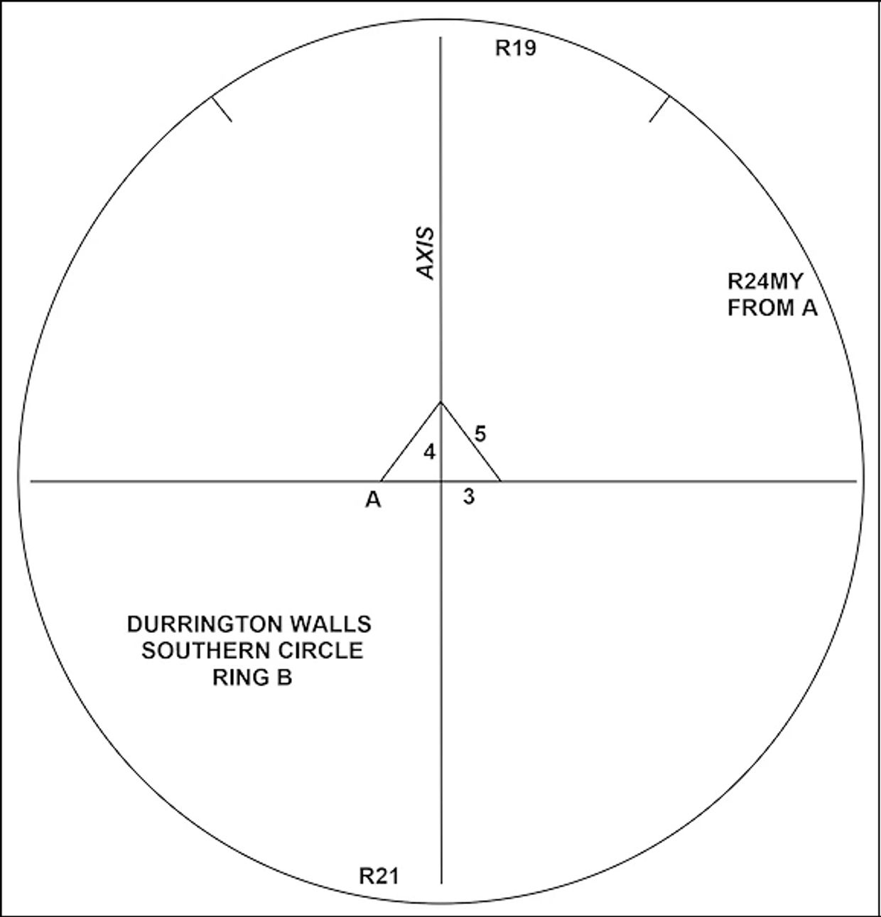
87. Ring B. Perfect geometric egg based on a pair of 3:4:5 Megalithic Yard triangles.

88. Ring C. Perfect egg based on identical 3:4:5 triangles.

89. Ring D. Perfect egg, again based on identical 3:4:5 Megalithic Yard triangles.
Furthermore, eggs B, C, and D obey the simple series...
Small radiuses: Ring B (19), deducting 3.5 gives Ring C (15.5), deducting 4 gives Ring D (11.5.)
Large radiuses: Ring B (21), deducting 3.5 gives Ring C (17.5), deducting 4 gives Ring D (13.5.)
Astonishingly, this series predicts the sizes of eggs E and G.

90. Rings E and G. Starting from the known Ring D…
Small radiuses: Ring D (11.5), deducting 4.5 gives Ring E (7), deducting 5 gives Ring G (2)
Large radiuses: Ring D (13.5), deducting 4.5 gives Ring E (9), deducting 5 gives Ring G (4.)
Ring F - the yolk - is circular at 13MY diameter.

91. Putting it all together. North is at the top.
The eggs of the Southern Circles all share the same major and minor axes.
Uniquely and precisely as predicted, the smallest egg is inside the yolk.
The major, or central axis, cuts through the incoming summer solstice sunset, just like the moon-aligned outer face of Stonehenge’s Heel Stone.
What went on at the centre of this device?

92. This is the ideal time and place to announce my newest acquisition. The source is on page 53 of "Megalithic Remains in Britain and Brittany" by Thom and Thom.
This is a rubbing of a cup and ring pecked on a stone in the garden of Cardrones House - somewhere in Scotland. Like Durrington's Southern Circle, the eggs are based on 3:4:5 perfect triangles and increase in size arithmetically. The pecked image is tiny by comparison, measured in Megalithic Inches. (One megalithic inch is equal to 0.8166 imperial inches)
A quote on Thom’s Perimeters:
"It is evident that it was considered important to have the perimeters as multiples of 2.5 units, and we suggest that this rule was given priority to the extent that it was allowed to control the radii, otherwise why did the designers use 4.625 MI for the largest radius?"
Unquote:
Answer: The designers did not. Thom and Thom stretched a point with the outer egg to make it conform to their unrealistic perimeter theory.

93. "Mossyard pecked stone," again from somewhere in Scotland. It is on page 52 of "Megalithic Remains in Britain and Brittany" by Thom and Thom.
Unbeknownst or overlooked by the Thoms and without interest in the hypothesis, these five rings start with a tiny 0.75 Megalithic Inch diameter pecking at their very centre. The rings that follow increase in arithmetical steps of 2.75: first by two circles and then three eggs. The largest circle is, therefore, 5.75 in diameter, not 5.5.
Mossyard is one further example of a monument that expresses growth. But what did prehistoric folks wish to grow? More to the point, what did they place inside the tiny cup for exposure to the sun? Seed of Barley, perhaps? A spoonful of egg yolk? Or might it have been some form of human DNA?
It's easy to imagine taking some eggs from a female's ovary, adding some sperm, and placing the mixture in the cup-shaped depression in the middle of these geometric eggs.
"They would then expose it to sunlight to observe its reaction."